GEOTECHNICAL ENGINEERING
REPENTIGNY
HomeUnderground ExcavationsGeotechnical excavation monitoring

Geotechnical Excavation Monitoring in Repentigny: Protecting Deep Cuts in Lanaudière Clay

Technical studies that support your project.

LEARN MORE

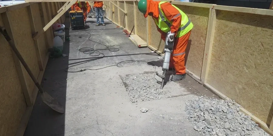
Between the dense residential fabric of Repentigny's Le Gardeur district and the commercial arteries of Boulevard Brien, you'll find two completely different excavation challenges. The former sits on thick, sensitive clay deposits near the L'Assomption River, while the latter cuts through compact glacial till that behaves more predictably. Our field team has been tracking these contrasts across the city for years, and in-situ permeability testing often reveals why groundwater management becomes the decisive factor in Le Gardeur. At a depth of six meters, the silty clay can turn a simple basement dig into a delicate exercise in slope stability, and without continuous geotechnical excavation monitoring, the margin for error shrinks fast.

In Repentigny's sensitive clay, a 10 mm displacement at the top of a shored excavation can indicate a far deeper problem than the same reading in glacial till — context is everything.

Our service areas

Our approach and scope

Repentigny sits at roughly 13 meters above sea level, with a population approaching 90,000 that keeps pushing development into areas once considered marginal for construction. The St. Lawrence Lowlands clay — known locally as 'argile sensible' — dominates much of the subsurface, and its sensitivity to disturbance means that excavation monitoring must track more than just movement. Our instrumentation packages typically combine automated inclinometers along the shoring face, piezometers spaced at two depths to capture perched water tables, and vibration sensors calibrated to NBCC thresholds when blasting or pile driving occurs within 100 meters of existing foundations. Data streams to an on-site datalogger every five minutes; the geotechnical engineer of record reviews trends daily, and we implement a three-tier alert protocol that triggers immediate review if lateral displacement exceeds 0.05% of wall height. The L'Assomption River corridor presents a unique scenario: seasonal fluctuations of up to 1.8 meters in river level alter pore pressures rapidly, so monitoring frequency doubles between March and May.
Geotechnical Excavation Monitoring in Repentigny: Protecting Deep Cuts in Lanaudière Clay
Technical reference — Repentigny

Local geotechnical context

A 14-story mixed-use project on Rue Notre-Dame three years back taught everyone on site a lesson in passive earth pressure. The contractor had soldier piles and lagging in place, but a week of heavy rain in late October saturated the backfill behind the wall. Our inclinometers caught a 9 mm lateral shift over 48 hours — still within design limits, but the acceleration rate was troubling. We recommended immediate dewatering and a temporary berm at the toe, and the movement stabilized within two days. Without geotechnical excavation monitoring, that gradual creep could have gone unnoticed until it became a sudden failure. Repentigny's clay has a memory: once disturbed, it can continue deforming for weeks, which is why we keep instruments in place through backfilling and never sign off on a reading that looks 'almost okay.' The CSA A23.3 standard guides concrete shoring design, but the real safety factor comes from watching the numbers change.

Need a geotechnical assessment?

Reply within 24h.

Email: info@geotechnical-engineering.org

Relevant standards

NBCC (National Building Code of Canada) — Part 4, structural design with seismic provisions, CSA A23.3 — Design of Concrete Structures, shoring and temporary works, ASTM D6230 — Standard Guide for Monitoring Well Installation, ASTM D7299 — Standard Practice for Verifying Inclinometer Probe Performance, CSA S832 — Seismic Risk Reduction of Operational and Functional Components

Technical data

ParameterTypical value
Monitoring frequency (active phase)Continuous with 5-min datalog intervals
Inclinometer accuracy±0.25 mm/m (MEMS digital probes)
Vibration threshold (PPV)15-25 mm/s per NBCC for adjacent buildings
Settlement monitoringOptical survey ±1 mm, weekly until stabilization
Piezometer range0-100 kPa, vibrating wire for long-term stability
Typical monitored depth5-18 m below grade in Repentigny
Alert protocol tiersGreen-Amber-Red with automated SMS notification

Questions and answers

What is the typical cost for geotechnical excavation monitoring in Repentigny?

Budgets in Repentigny generally range from CA$1,100 to CA$3,180 depending on the number of monitoring stations, duration of the project, and whether vibrating wire piezometers are required for groundwater control. A small commercial excavation with two inclinometer stations and monthly surveys sits at the lower end; a deep shored cut with continuous automated monitoring and vibration sensors near occupied buildings reaches the higher range.

How long should monitoring continue after the excavation is backfilled?

We keep instruments running for at least 30 days after backfill completion in Repentigny's clay soils. Sensitive clay can continue to readjust pore pressure equilibrium long after the excavation is closed, and we've recorded settlement of adjacent sidewalks two months post-backfill in the Le Gardeur area.

Does NBCC require vibration monitoring for all urban excavations?

NBCC Part 4 and CSA S832 provide performance-based guidelines rather than blanket mandates. However, when excavation or pile driving occurs within 100 meters of existing buildings — common in central Repentigny — vibration monitoring becomes the accepted standard of care, and municipal permits often require a monitoring plan before shoring begins.

What instrumentation is most critical for the L'Assomption River corridor?

Piezometers are non-negotiable near the river. The L'Assomption's seasonal level changes by up to 1.8 meters, and that directly affects pore water pressure behind shoring walls. We install at least two vibrating wire piezometers at different depths to capture the vertical gradient, and read them daily during spring thaw.

Location and service area

We serve projects in Repentigny and surrounding areas.

View larger map